|
FACTS ABOUT KARNATAKA
Situated on a tableland where the Western and Eastern Ghat ranges converge
into the Nilgiri hill complex, the State of Karnataka is confined roughly within 11.5 degree North and 18.5 degree North latitudes
and 74 degree East and 78.5 degree East longitude.
The State is bounded by Maharashtra and Goa States in the North
and North-West; by the Arabian sea in the West; by Kerala and Tamilnadu States in the South and by the State of Andhra Pradesh
in the East. The State extends to about 750 km from North to South and about 400 km from East to West, and covers an area
of about 1,91,791 sq.km.
- Karnataka Population: 5.273 crore (52.73 million)
- Urban Population : 33.98%
- Rural Population : 66.01%
Sex Ratio
- Overall average - 964 females per 1,000 males
- Urban -
940/1000
- Rural
- 976/1000
Literacy
- Total - 67.04 %
- Urban - 81.05 % to 74.20 %
- Rural - 47.69 % to 59.68 %
Karnataka's total land area is 1,91,791 sq.km. It accounts for 5.83 percent
of the total area of the country (32.88 lakh sq.km) and ranks eighth among major States of the country in terms of size.
Among different states, Karnataka occupies eighth place with regard to population.
The density of population as per 1991 Census was 235 persons per sq.km which was lower than the all-India density of 273 (excluding
Assam and Jammu and Kashmir).
Among the states, Karnataka was in the thirteenth position. Bijapur
(my District) occupies the largest geographical area of the State with 8.89 per cent and Bangalore (urban)
Dt. has the smallest area with only 1.94 per cent.
There are seven river basins with which their tributaries drain the State. The river systems include:
- Krishna
- Cauvery
- Godavari
- West flowing rivers
- North Pennar
- South Pennar
- Palar
Both day and night temperatures
are more or less uniform over the State, except at the coastal region and high elevated plateau. They generally decrease south-westwards
over the State due to higher elevation and attain lower values at high level stations. April and May are the hottest months.
In May, mean maximum temperature shoots upto 40 deg. C over the north-eastern corner of the State, decreasing south-westwards
towards the Western Ghat region and the Coastal belt.
Major Minerals:
Gold (90% of India's production), iron ore, manganese, maganesite.
Premier Educational Centres:
1.Indian Institute of Science, Raman Research Institute,
2.National Institute of Mental Health and Neuro-Sciences,
3. Central Food Technological Research Institute.
4. Indian Space Research Organisation.
5. National Aeronautical Laboratory.
6. National Institute for Sports(South).
Religion:
Hindus, Jains, Muslims,
Christians
Seasons:
Summer: March to May (18oC to 40oC);
Winter: March
to May (14oC to 32oC);
South-West Monsoon: June to August;
North-East Monsoon: October to December
Like to know more about karnataka, click the below address.
http://kstdc.nic.in/
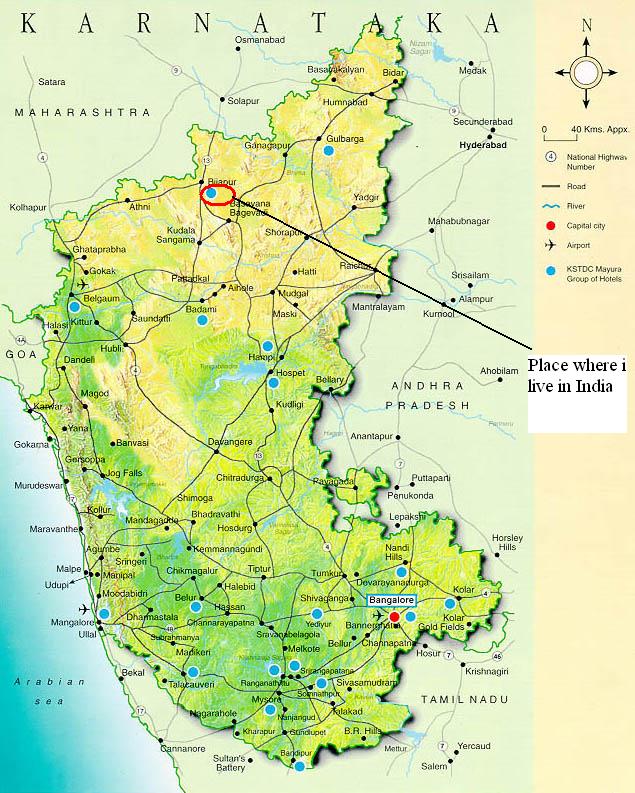
ABOUT MY DISTRICT
Bijapur : A historical destination
530 kms to the north-west of Bangalore is the ancient town of Bijapur,
the capital of the Adil Shahi dynasty. Bijapur is close to Belgaum - the gateway to Karnataka from Goa and Bombay. Bijapur
has many places of Historical, Cultural and Architectural interest.
Local sites
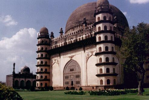
Gol Gumbaz
| The tomb of Mohammed Adil Shah, boasts of the second-largest tomb in the world.44
m in diameter, the interior of the dome is mysteriously unsupported and has a whispering gallery under it, whose acoustics
are superb. Located in the north-eastern part of Karnataka, Bijapur used to be the home of the Bahamani Sultans the most illustrous
of whom was the Adil Shah. Adil Shah began the task of building his own tomb, quite earnestly and went on with this work for
over 20 years. |
Jumma Masjid
Jumma Masjid is the other attraction of this city. Jumma Masjid still
used for worship, has been called one of the first mosques in India. It holds an exquisite copy of the Quran, written in gold.
Also dating back to the period of Adil Shah this is the largest Masjid in the region. Barah Cummon (12 arches) is another
wonderful piece of architecture created simply with twelve interleaving arches as a centre stage for art festivities.
Places to visit around Bijapur
Aihole
This Temple city is 110 kms away from Bijapur. It is famous as the 'Cradle of Indian Temple Architecture'. Aihole has
over 125 temples all intricately carved and rich in detail. The oldest temple here, is perhaps the 5th century Lad Khan Temple.
The Durga (Fort) Temple has a semi-circular apse and a complete portico. The Hutchmalli Temple, the Ravalphadi Cave Temple,
The Konti Temple Complex, The Uma Maheshwari Temple , The Jain Meguthi Temple and The Two-storeyed Buddhist Temple are the
other attractions at Aihole.
Pattadakal
Pattadakal has a distance of 134 kms from Bijapur. A world Heritage Center, it
has 10 major temples representing early Chalukyan architecture. The biggest temple dedicated to Virupaksheshvara, has a huge
gateway and several inscriptions. In front of the temple is a majestic 2.6 in high Nandi. The Mallikarjuna and Papanatha Temples,
and the Jain Temple rom the Papanatha Temples and the Jain Temple from the Rashtrakuta period are well worth visit.
Badami
About 120 kms from Bijapur. The capital of the early Chalukyas, Badami is picturesquely situated
at the mouth of a ravine between two rocky hills. It has four rock - cut cave temples, the largest being the third cave dedicated
to Vishnu. Overlooking the temples is a reservoir , its banks dotted with temples dedicated to Vishnu and Shiva. The Bhutanatha
Temples and the Museum set up by the Archaeological Survey of India, are the other attractions.
Basavana Bagewadi
About 43 kms from Bijapur, this town is the Birth-place of Saint Basaveshwara. There are several
important temples here.
Kudalasangama
67 kms from Bijapur is a famous pilgrim centre,
associated with the great 12th century poet and reformer Saint Basaveshwara.
Essentials
Getting Here
Bijapur is well-connected by road and rail to Bangalore, Belgaum
and Goa. The nearest airport is Belgaum, 205 kms away.
Where to stay
- Hotel Mayura Adhil Shahi.
- Hotel Mayura Adhil Shahi Annexe.
- Hotel Sanman, Station Road.
- Hotel Samrat, Station Road.
- Hotel Madhuvan International,Station Road.
Shopping:
Bijapur is famous for its hand woven Ilkal sarees.
Climate:
The ideal tome to travel here is September-February.
Local Food Specialities:
Non-vegetarian preparations distinctly Mughlai
or Hyderabadi, Milk Sweets.
| Gol Gumbaz, bijapur |
|
| Worlds second largest tomb. famous in India |
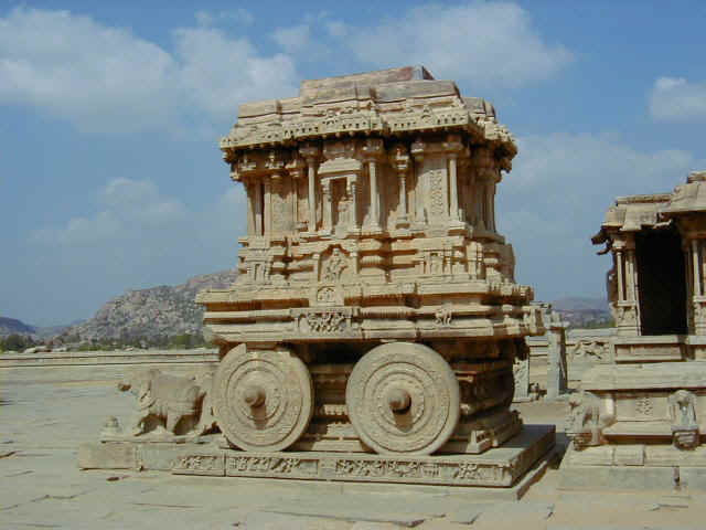
| HAMPI RATHA |
|
| THE PLACE HAMPI IS FAMOUS FOR ITS HISTORY AND TEMPLES |
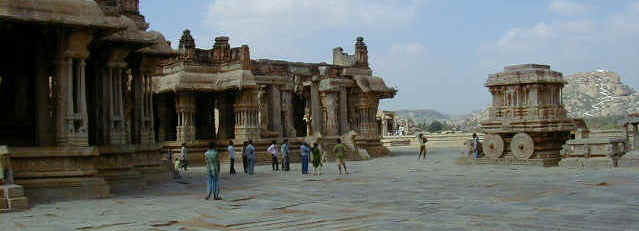
| VIJAYA TEMPLE |
|
| VIJAYA TEMPLE IS IN HAMPI, NEAR TO BIJAPUR |
|